
Indigenous Fire-Managed Landscapes in Southeast Australia during the Holocene—New Insights from the Furneaux Group Islands, Bass Strait

 ,
,  , and
, and
Abstract
:1. Introduction
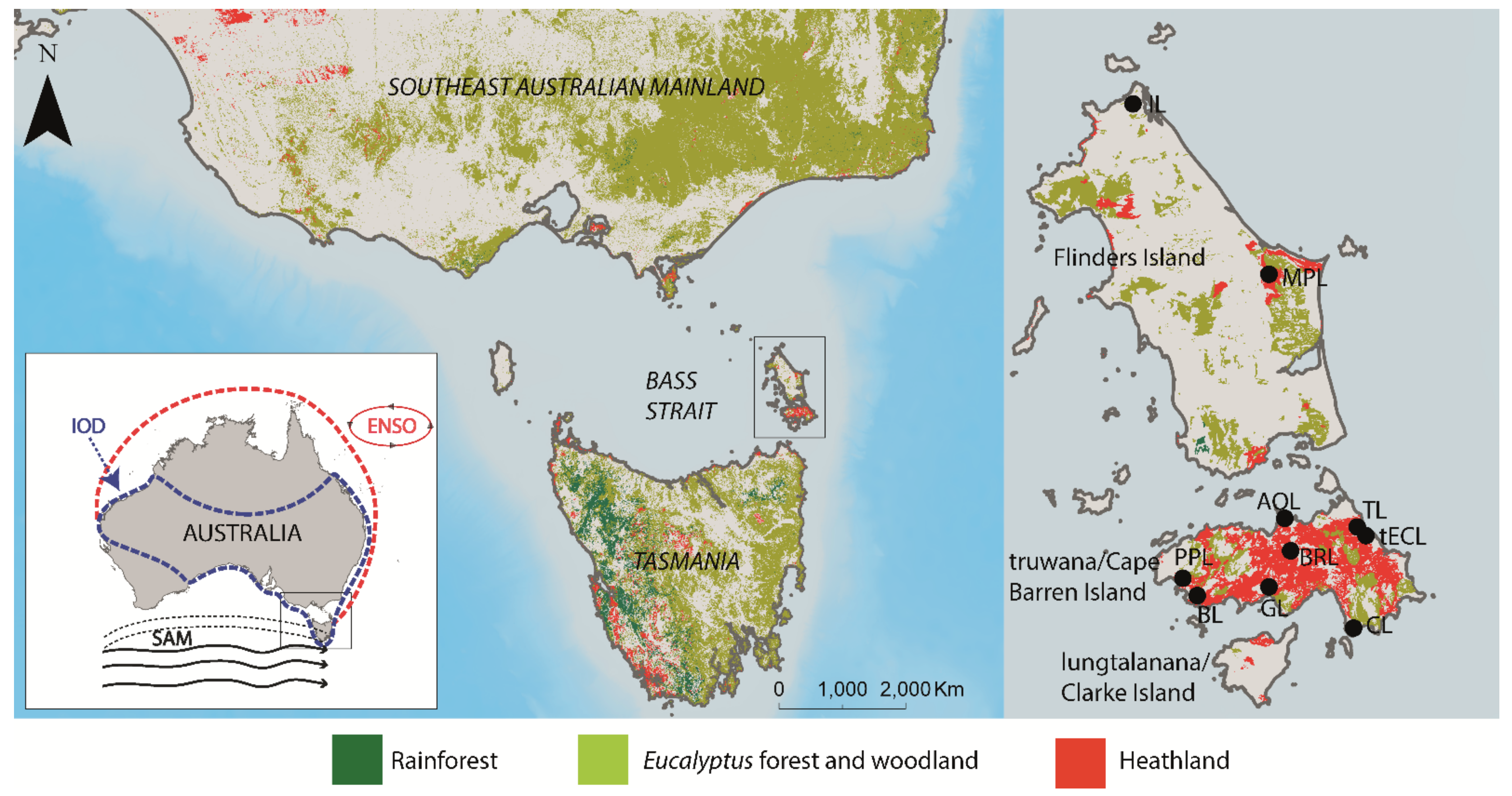
1.1. Study Region
1.1.1. Dominant Climatic Modes in Bass Strait and Southeast Australia
1.1.2. Vegetation
1.1.3. Past Human Occupation
2. Materials and Methods
2.1. Composite Charcoal Influx as a Proxy for Vegetation Biomass Burned (BB)
2.2. Charcoal Influx Peak Component as a Proxy for Recurrence-Rate-of-Fire-Episodes (RRFE)
2.3. Identifying Drivers of Fire Regimes across Southeast Australian Regions Using Generalized Linear Modelling
3. Results
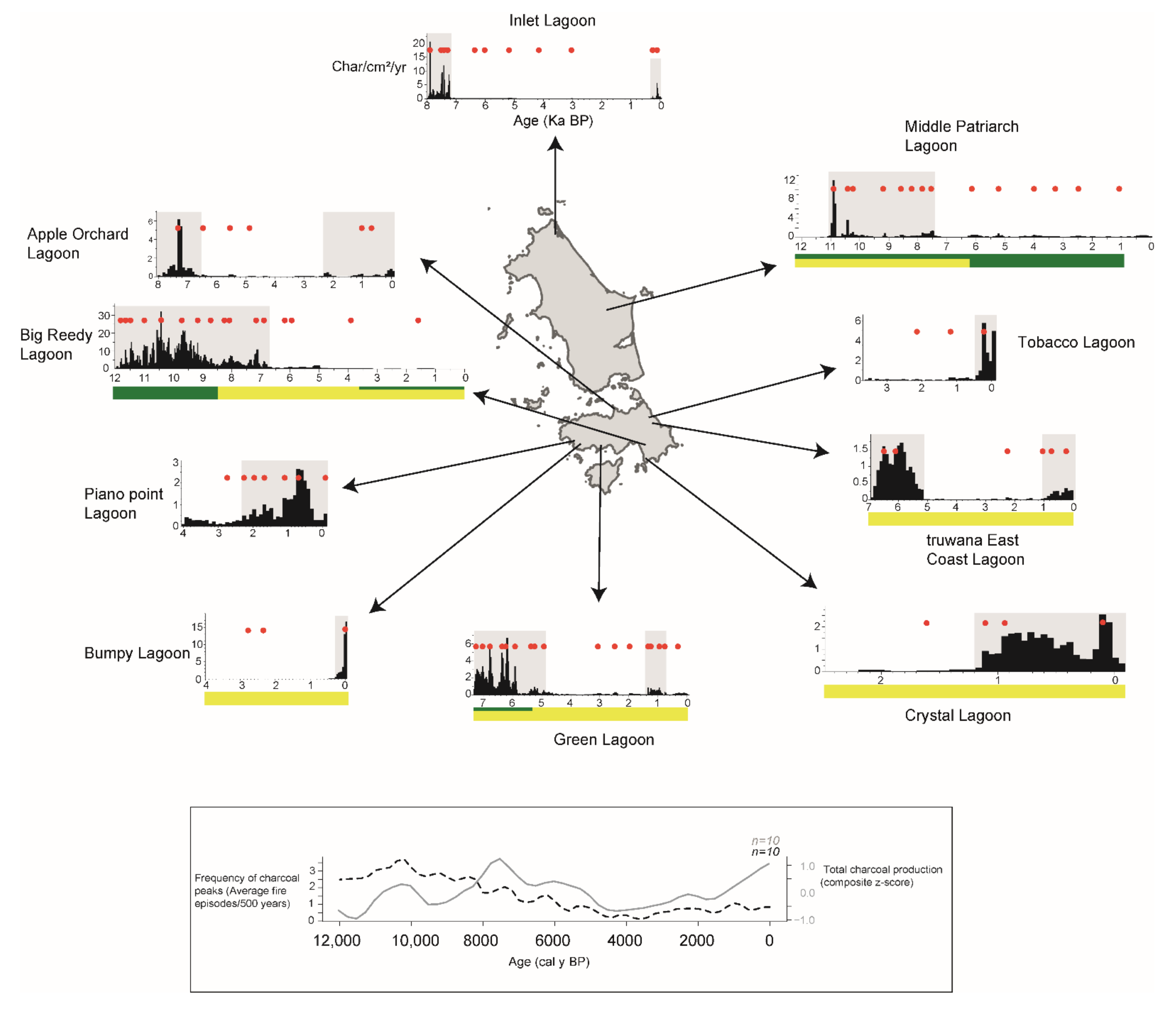
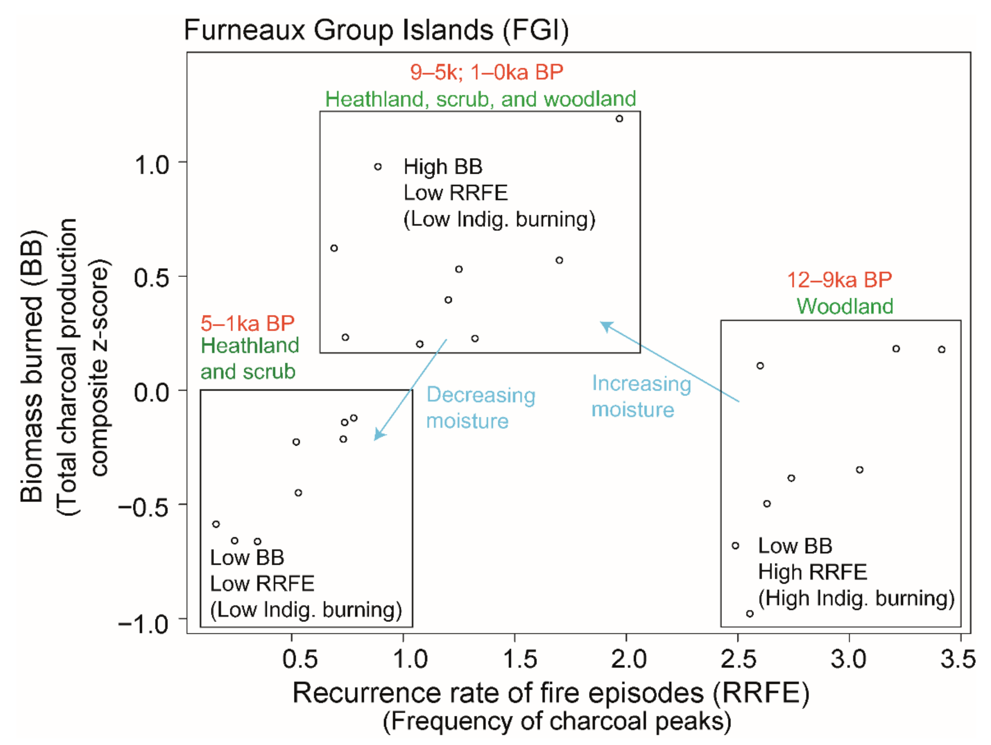
3.1. FGI Holocene Regional Palaeofire Reconstruction
3.2. FGI Holocene Palaeofire Compared to Other Southeast Australian Regions
4. Discussion
4.1. Potential Sources of Error
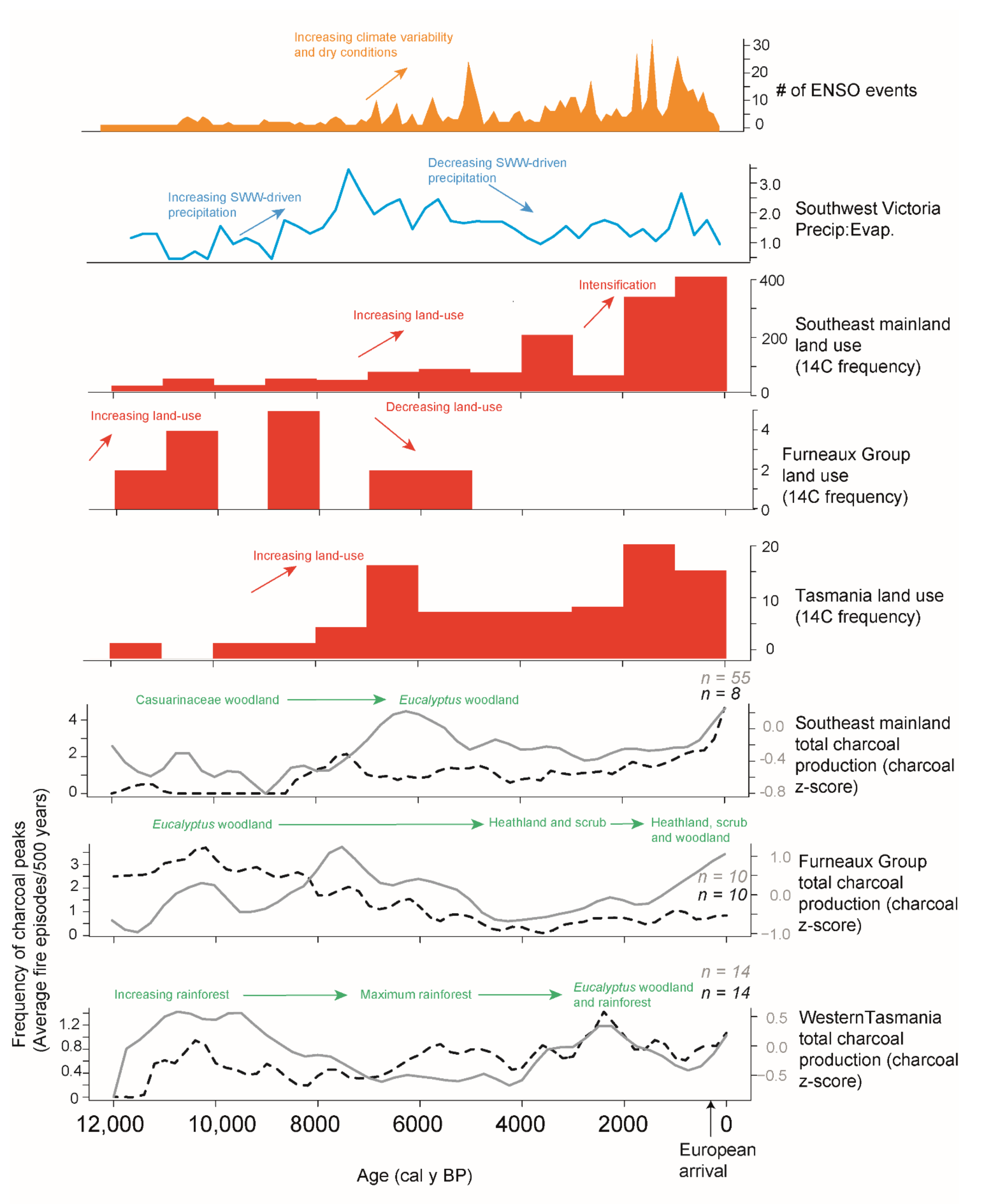
4.2. Holocene Drivers of Biomass Burned (BB) in Southeast Australia: SWW-Driven Effective Precipitation and ENSO
4.3. Holocene Drivers of Recurrence Rate of Fire Episodes (RRFE) in Southeast Australia: Anthropogenic Land Use
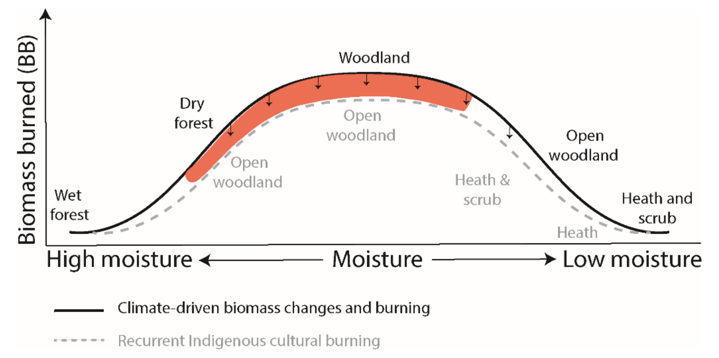
4.4. Australian Fire Regime and Management
5. Conclusions
Supplementary Materials
Author Contributions
Funding
Institutional Review Board Statement
Informed Consent Statement
Data Availability Statement
Acknowledgments
Conflicts of Interest
References
- Crisp, M.; Burrows, G.; Cook, L.; Thornhill, A.H.; Bowman, D.M.J.S. Flammable biomes dominated by eucalypts originated at the Cretaceous–Palaeogene boundary. Nat. Commun. 2011, 2, 193. [Google Scholar] [CrossRef] [Green Version]
- Gill, A.M. Fire and the Australian flora: A review. Aust. For. 1975, 38, 1–25. [Google Scholar] [CrossRef]
- Beadle, N.C.W. The Vegetation of Australia; Cambridge University Press: Cambridge, UK, 1981. [Google Scholar]
- Miller, B.P.; Murphy, B.P. Fire and Australian Vegetation. In Australian Vegetation, 3rd ed.; Keith, D.A., Ed.; Cambridge University Press: Cambridge, UK, 2017; pp. 113–134. [Google Scholar]
- Murphy, B.P.; Bradstock, R.A.; Boer, M.M.; Carter, J.; Cary, G.J.; Cochrane, M.A.; Fensham, R.J.; Russell-Smith, J.; Williamson, G.J.; Bowman, D.M. Fire regimes of Australia: A pyrogeographic model system. J. Biogeogr. 2013, 40, 1048–1058. [Google Scholar] [CrossRef]
- Bradstock, R.A. A biogeographic model of fire regimes in Australia: Current and future implications. Glob. Ecol. Biogeogr. 2010, 19, 145–158. [Google Scholar] [CrossRef]
- Mooney, S.D.; Harrison, S.P.; Bartlein, P.J.; Daniau, A.L.; Stevenson, J.; Brownlie, K.C.; Buckman, S.; Cupper, M.; Luly, J.; Black, M.; et al. Late Quaternary fire regimes of Australasia. Quat. Sci. Rev. 2011, 30, 28–46. [Google Scholar] [CrossRef]
- Whitehair, L.; Fulé, P.Z.; Meador, A.S.; Azpeleta Tarancón, A.; Kim, Y.S. Fire regime on a cultural landscape: Navajo Nation. Ecol. Evol. 2018, 8, 9848–9858. [Google Scholar] [CrossRef] [PubMed]
- Archibald, S.; Caroline, E.R.L.; Gómez-Dans, J.L.; Bradstock, R.A. Defining pyromes and global fire regimes. Proc. Natl. Acad. Sci. USA 2013, 110, 6442–6447. [Google Scholar] [CrossRef] [Green Version]
- Bowman, D.M.J.S. The impact of Aboriginal landscape burning on the Australian biota. New Phytol. 1998, 140, 385–410. [Google Scholar] [CrossRef]
- Gammage, B. Plain facts: Tasmania under aboriginal management. Landsc. Res. 2008, 33, 241–254. [Google Scholar] [CrossRef]
- Bird, R.B.; McGuire, C.; Bird, D.W.; Price, M.H.; Zeanah, D.; Nimmo, D.G. Fire mosaics and habitat choice in nomadic foragers. Proc. Natl. Acad. Sci. USA 2020, 117, 12904–12914. [Google Scholar] [CrossRef]
- Bowman, D.M.J.S.; Walsh, A.; Prior, L.D. Landscape analysis of Aboriginal fire management in Central Arnhem Land, North Australia. J. Biogeogr. 2004, 31, 207–223. [Google Scholar] [CrossRef]
- Black, M.P.; Mooney, S.D. Holocene fire history from the Greater Blue Mountains World Heritage Area, New South Wales, Australia: The climate, humans and fire nexus. Reg. Environ. Chang. 2006, 6, 41–51. [Google Scholar] [CrossRef]
- Black, M.P.; Mooney, S.D.; Attenbrow, V. Implications of a 14200-year contiguous fire record for understanding human–climate relationships at Goochs Swamp, New South Wales, Australia. Holocene 2008, 18, 437–447. [Google Scholar] [CrossRef]
- Fletcher, M.S.; Wolfe, B.B.; Whitlock, C.; Pompeani, D.P.; Heijnis, H.; Haberle, S.G.; Gadd, P.S.; Bowman, D.M.J.S. The legacy of mid-Holocene fire on a Tasmanian montane landscape. J. Biogeogr. 2013, 41, 476–488. [Google Scholar] [CrossRef]
- Fletcher, M.S.; Bowman, D.M.J.S.; Whitlock, C.; Mariani, M.; Stahle, L. The changing role of fire in conifer-dominated temperate rainforest through the last 14,000 years. Quat. Sci. Rev. 2018, 182, 37–47. [Google Scholar] [CrossRef]
- Stahle, L.N.; Whitlock, C.; Haberle, S.G. A 17,000-Year-Long Record of Vegetation and Fire from Cradle Mountain National Park, Tasmania. Front. Ecol. Evol. 2016, 4, 82. [Google Scholar] [CrossRef] [Green Version]
- Stahle, L.N.; Chin, H.; Haberle, S.; Whitlock, C. Late-glacial and Holocene records of fire and vegetation from Cradle Mountain National Park, Tasmania, Australia. Quat. Sci. Rev. 2017, 177, 57–77. [Google Scholar] [CrossRef]
- McWethy, D.B.; Higuera, P.E.; Whitlock, C.; Veblen, T.T.; Bowman, D.M.J.S.; Cary, G.J.; Haberle, S.G.; Keane, R.E.; Maxwell, B.D.; McGlone, M.S.; et al. A conceptual framework for predicting temperate ecosystem sensitivity to human impacts on fire regimes. Glob. Ecol. Biogeogr. 2013, 22, 900–912. [Google Scholar] [CrossRef]
- Romano, A.; Fletcher, M.S. Evidence for reduced environmental variability in response to increasing human population growth during the late Holocene in northwest Tasmania, Australia. Quat. Sci. Rev. 2018, 197, 193–208. [Google Scholar] [CrossRef]
- Mooney, S.D.; Webb, D.; Attenbrow, V. A comparison of charcoal and archaeological information to address the Influences on Holocene fire activity in the Sydney Basin. Aust. Geogr. 2007, 38, 177–194. [Google Scholar] [CrossRef]
- Williams, A.N.; Ulm, S.; Smith, M.; Reid, J. AustArch: A Database of 14C and Non-14C Ages from Archaeological Sites in Australia-Composition, Compilation and Review (Data Paper). Internet Archaeol. 2014, 36, 1–12. [Google Scholar] [CrossRef]
- Lourandos, H. A Late Pleistocene-Holocene Archaeological Sequence from Southwestern Victoria. Archaeol. Ocean. 1983, 18, 81–94. [Google Scholar] [CrossRef]
- Sim, R. The Archaeology of Isolation? Prehistoric Occupation in the Furneaux Group of Islands, Bass Strait, Tasmania. Ph.D. Thesis, Australian National University, Canberra, Australia, 1998. [Google Scholar]
- Hargrove, W.W.; Pickering, J. Pseudoreplication: A sine qua non for regional ecology. Landsc. Ecol. 1992, 6, 251–258. [Google Scholar] [CrossRef]
- Vachula, R.S. A meta-analytical approach to understanding the charcoal source area problem. Palaeogeogr. Palaeoclimatol. Palaeoecol. 2020, 562, 110111. [Google Scholar] [CrossRef]
- Duffin, K.I.; Gillson, L.; Willis, K.J. Testing the sensitivity of charcoal as an indicator of fire events in savanna environments: Quantitative predictions of fire proximity, area and intensity. Holocene 2008, 18, 279–291. [Google Scholar] [CrossRef]
- Tinner, W.; Conedera, M.; Ammann, B.; Gaggeler, H.W.; Gedye, S.; Jones, R.; Sagesser, B. Pollen and charcoal in lake sediments compared with historically documented forest fires in southern Switzerland since AD 1920. Holocene 1998, 8, 31–42. [Google Scholar]
- Ali, A.A.; Blarquez, O.; Girardin, M.P.; Hély, C.; Tinquaut, F.; El Guellab, A.; Valsecchi, V.; Terrier, A.; Bremond, L.; Genries, A.; et al. Control of the multimillennial wildfire size in boreal North America by spring climatic conditions. Proc. Natl. Acad. Sci. USA 2012, 109, 20966–20970. [Google Scholar] [CrossRef] [PubMed] [Green Version]
- Carcaillet, C.; Almquist, H.; Asnong, H.; Bradshaw, R.H.W.; Carrión, J.S.; Gaillard, M.J.; Gajewski, K.; Haas, J.N.; Haberle, S.G.; Hadorn, P.; et al. Holocene biomass burning and global dynamics of the carbon cycle. Chemosphere 2002, 49, 845–863. [Google Scholar] [CrossRef]
- Carcaillet, C.; Bergman, I.; Delorme, S.; Hornberg, G.; Zackrisson, O. Long-term fire frequency not linked to prehistoric occupations in northern swedish boreal forest. Ecology 2007, 88, 465–477. [Google Scholar] [CrossRef]
- Blarquez, O.; Vannière, B.; Marlon, J.R.; Daniau, A.; Power, M.J.; Brewer, S.; Bartlein, P.J. Paleofire: An R package to analyse sedimentary charcoal records from the Global Charcoal Database to reconstruct past biomass burning. Comput. Geosci. 2014, 72, 255–261. [Google Scholar] [CrossRef]
- Higuera, P.E.; Gavin, D.G.; Bartlein, P.J.; Hallett, D.J. Peak detection in sediment–charcoal records: Impacts of alternative data analysis methods on fire-history interpretations. Int. J. Wildland Fire 2010, 19, 996–1014. [Google Scholar] [CrossRef]
- Adolf, C.; Wunderle, S.; Colombaroli, D.; Weber, H.; Gobet, E.; Heiri, O.; van Leeuwen, J.F.N.; Bigler, C.; Connor, S.E.; Gałka, M.; et al. The sedimentary and remote-sensing reflection of biomass burning in Europe. Glob. Ecol. Biogeogr. 2018, 27, 199–212. [Google Scholar]
- CSIRO. Climate and Water Availability in South-Eastern Australia: A Synthesis of Findings from Phase 2 of the South. Eastern Australian Climate Initiative (SEACI); CSIRO: Canberra, Australia, 2012; p. 41. [Google Scholar]
- Abram, N.J.; Wright, N.M.; Ellis, B.; Dixon, B.C.; Wurtzel, J.B.; England, M.H.; Ummenhofer, C.C.; Philibosian, B.; Cahyarini, S.Y.; Yu, T.; et al. Coupling of Indo-Pacific climate variability over the last millennium. Nature 2020, 579, 385–392. [Google Scholar] [CrossRef] [PubMed]
- Fierro, A.O.; Leslie, L.M. Relationships between Southeast Australian Temperature Anomalies and Large-Scale Climate Drivers. J. Clim. 2014, 27, 1395–1412. [Google Scholar] [CrossRef]
- Risbey, J.S.; Pook, M.J.; McIntosh, P.C.; Wheeler, M.C.; Hendon, H.H. On the remote drivers of rainfall variability in Australia. Mon. Weather Rev. 2009, 137, 3233–3253. [Google Scholar] [CrossRef]
- Australian Bureau of Meteorology. Southern Annular Mode in Australia. Available online: http://www.bom.gov.au/climate/sam/images/SAM-in-Australia.pdf (accessed on 24 January 2020).
- Hendon, H.H.; Thompson, D.W.J.; Wheeler, M.C. Australian rainfall and surface temperature variations associated with the Southern Hemisphere Annular Mode. J. Clim. 2007, 20, 2452–2467. [Google Scholar] [CrossRef]
- Mariani, M.; Fletcher, M.S.; Holz, A.; Nyman, P. ENSO controls interannual fire activity in southeast Australia. Geophys. Res. Lett. 2016, 43, 10–891. [Google Scholar] [CrossRef] [Green Version]
- Mariani, M.; Holz, A.; Veblen, T.T.; Williamson, G.; Fletcher, M.S.; Bowman, D.M.J.S. Climate change amplifications of climate-fire teleconnections in the Southern Hemisphere. Geophys. Res. Lett. 2018, 45, 5071–5081. [Google Scholar] [CrossRef]
- Fletcher, M.S.; Moreno, P.I. Have the Southern Westerlies changed in a zonally symmetric manner over the last 14,000 years? A hemisphere-wide take on a controversial problem. Quat. Int. 2012, 253, 32–46. [Google Scholar] [CrossRef]
- Williamson, G.J.; Prior, L.D.; Jolly, W.M.; Cochrane, M.A.; Murphy, B.P.; Bowman, D.M. Measurement of inter-and intra-annual variability of landscape fire activity at a continental scale: The Australian case. Environ. Res. Lett. 2016, 11, 035003. [Google Scholar] [CrossRef] [Green Version]
- Keith, D.A. Australian Vegetation, 3rd ed.; Cambridge University Press: Cambridge, UK, 2017. [Google Scholar]
- Harris, S.; Buchanan, A.; Connolly, A. One Hundred Islands: The Flora of the Outer Furneaux; Tasmanian Department of Primary Industries, Water and Environment: Hobart, Australia, 2001.
- Harris, S.; Kitchener, A. From Forest to Fjaeldmark. Descriptions of Tasmaniaߣs Vegetation; Department of Primary Industries, Water and Environment: Hobart, Australia, 2005.
- Kershaw, A.P.; D’Costa, D.M.; McEwen Mason, J.R.C.; Wagstaff, B.E. Palynological evidence for Quaternary vegetation and environments of mainland southeastern Australia. Quat. Sci. Rev. 1991, 10, 391–404. [Google Scholar] [CrossRef]
- Mackenzie, L.; Moss, P. A late Quaternary record of vegetation and climate change from Hazards Lagoon, eastern Tasmania. Quat. Int. 2017, 432, 58–65. [Google Scholar] [CrossRef]
- Jones, P.J.; Thomas, I.; Fletcher, M.-S. Long-term environmental change in eastern Tasmania: Vegetation, climate and fire at Stoney Lagoon. Holocene 2017, 27, 1340–1349. [Google Scholar] [CrossRef] [Green Version]
- McWethy, D.B.; Haberle, S.G.; Hopf, F.; Bowman, D.M.J.S. Aboriginal impacts on fire and vegetation on a Tasmanian Island. J. Biogeogr. 2017, 44, 1319–1330. [Google Scholar] [CrossRef]
- Adeleye, M.A.; Haberle, S.G.; Harris, S.; Hopf, F.V. Holocene heathland development in temperate oceanic Southern Hemisphere—Key drivers in a global context. J. Biogeogr. 2021. [Google Scholar]
- Cosgrove, R. Late Pleistocene behavioural variation and time trends: The case from Tasmania. Archaeological 1995, 30, 83–104. [Google Scholar] [CrossRef]
- Lambeck, K.; Chappell, J. Sea level change through the last Glacial cycle. Science 2001, 292, 679–686. [Google Scholar] [CrossRef]
- Sloss, C.R.; Murray-Wallace, C.V.; Jones, B.G. Holocene sea level change on the southeast coast of Australia: A review. Holocene 2007, 17, 999–1014. [Google Scholar] [CrossRef]
- Williams, A.N.; Ulm, S.; Sapienza, T.; Lewis, S.; Turney, C.M.S. Sea-level change and demography during the last glacial termination and early Holocene across the Australian continent. Quat. Sci. Rev. 2018, 182, 44–154. [Google Scholar] [CrossRef]
- Geoscience Australia. Australian Bathymetry and Topography. 2016. Available online: http://creativecommons.org/licenses/by/4.0/legalcode (accessed on 24 January 2021).
- Department of Agriculture, Water and Environment. National Vegetation Information System (NVIS) Version 5.1. Available online: https://www.environment.gov.au/land/native-vegetation/national-vegetation-information-system/data-products (accessed on 18 June 2020).
- Power, M.J.; Marlon, J.; Ortiz, N.; Bartlein, P.J.; Harrison, S.P.; Mayle, F.E.; Ballouche, A.; Bradshaw, R.H.W.; Carcaillet, C.; Cordova, C.; et al. Changes in fire regimes since the Last Glacial Maximum: An assessment based on a global synthesis and analysis of charcoal data. Clim. Dyn. 2008, 30, 887–907. [Google Scholar]
- Marlon, J.R.; Kelly, R.; Daniau, A.L.; Vannière, B.; Power, M.J.; Bartlein, P.; Higuera, P.; Blarquez, O.; Brewer, S.; Brücher, T.; et al. Reconstructions of biomass burning from sediment-charcoal records to improve data–model comparisons. Biogeosciences 2016, 13, 3225–3244. [Google Scholar] [CrossRef] [Green Version]
- Whitlock, C.; Larsen, C. Charcoal as fire proxy. In Tracking Environmental Change Using Lake Sediments: Terrestrial, Algal, and Siliceous Indicators; Smol, J.P., Briks, H.J., Last, W.M., Eds.; Kluwer Academic Publishers: Dordrecht, The Netherlands, 2001. [Google Scholar]
- R Core Team. Core. R: A Language and Environment for Statistical Computing (Version 3. 6. 0); R Foundation for Statistical Computing: Vienna, Austria, 2019. [Google Scholar]
- Higuera, P.E.; Peters, M.E.; Brubaker, L.B.; Gavin, D.G. Understanding the origin and analysis of sediment charcoal records with a simulation model. Quat. Sci. Rev. 2007, 26, 1790–1809. [Google Scholar] [CrossRef]
- Higuera, P.E.; Brubaker, L.B.; Anderson, P.M.; Hu, F.S.; Brown, T.A. Vegetation mediated the impacts of postglacial climate change on fire regimes in the south-central Brooks Range, Alaska. Ecol. Monogr. 2009, 79, 201–219. [Google Scholar] [CrossRef]
- Gosling, W.D.; Cornelissen, H.L.; McMichael, C.N.H. Reconstructing past fire temperatures from ancient charcoal material. Palaeogeogr. Palaeoclimatol. Palaeoecol. 2019, 520, 128–137. [Google Scholar] [CrossRef]
- Mellin, C.; Bradshaw, C.J.A.; Meekan, M.G.; Caley, M.J. Environmental and spatial predictors of species richness and abundance in coral reef fishes. Glob. Ecol. Biogeogr. 2010, 19, 212–222. [Google Scholar] [CrossRef]
- Cryer, J.; Chan, K. Time Series Analysis with Applications in R (Second Edition). 2012. Available online: http://www.stat.uiowa.edu/~kchan/TSA.htm (accessed on 24 January 2021).
- Millard, S.P. EnvStats: An R Package for Environmental Statistics; Springer: New York, NY, USA, 2013; Available online: http://www.springer.com (accessed on 24 January 2021).
- Moy, C.M.; Seltzer, G.O.; Seltzer, D.T.; Anderson, D.M. Variability of El Niño/Southern Oscillation activity at millennial time scales during the Holocene epoch. Nature 2002, 420, 162–165. [Google Scholar] [CrossRef]
- Wilkins, D.; Gouramanis, C.; De Deckker, P.; Fifield, L.K.; Olley, J. Holocene lake-level fluctuations in Lakes Keilambete and Gnotuk, southwestern Victoria, Australia. Holocene 2013, 23, 784–795. [Google Scholar]
- Ladd, P.G.; Orchiston, D.W.; Joyce, E.B. Holocene vegetation history of Flinders Island. New Phytol. 1992, 122, 757–767. [Google Scholar] [CrossRef] [Green Version]
- Hopf, F.V.L.; Colhoun, E.A.; Barton, C.E. Late-glacial and Holocene record of vegetation and climate from Cynthia Bay, Lake St Clair, Tasmania. Quat. Sci. 2000, 15, 725–732. [Google Scholar] [CrossRef]
- Timpson, A.; Colledge, S.; Crema, E.; Edinborough, K.; Kerig, T.; Manning, K.; Thomas, M.G.; Shennan, S. Reconstructing regional population fluctuations in the European Neolithic using radiocarbon dates: A new case-study using an improved method. J. Archaeol. Sci. 2014, 52, e549–e557. [Google Scholar] [CrossRef] [Green Version]
- Crema, E.R.; Habu, J.; Kobayashi, K.; Madella, M. Summed probability distribution of 14C dates suggests regional divergences in the population dynamics of the Jomon period in eastern Japan. PLoS ONE 2016, 11, e0154809. [Google Scholar] [CrossRef] [PubMed] [Green Version]
- Williams, A.N. The use of summed radiocarbon probability distributions in archaeology: A review of methods. J. Archaeol. Sci. 2012, 39, e578–e589. [Google Scholar] [CrossRef]
- Williams, A.N.; Ulm, S.; Turney, C.S.M.; Rodhe, D.; White, G. The establishment of complex society in prehistoric Australia: Demographic and mobility changes in the late Holocene. PLoS ONE 2015, 10, e0128661. [Google Scholar]
- Williams, A.N.; Veth, P.M.; Steffen, W.; Ulm, S.; Turney, C.S.M.; Reeves, J.; Phipps, S.; Smith, M. A continental narrative: Human settlement patterns and Australian climate change over the last 35,000 years. Quat. Sci. Rev. 2015, 123, e91–e112. [Google Scholar] [CrossRef]
- Cochrane, M.A. Tropical Fire Ecology: Climate Change, Land Use and Ecosystem Dynamics; Praxis Publishing Ltd.: Chichester, UK, 2009. [Google Scholar]
- Pausas, J.G.; Paula, S. Fuel shapes the fire–climate relationship: Evidence from Mediterranean ecosystems. Glob. Ecol. Biogeogr. 2012, 21, 1074–1082. [Google Scholar] [CrossRef]
- Pausas, J.G.; Bradstock, R.A. Fire persistence traits of plants along a productivity and disturbance gradient in Mediterranean shrublands of south-east Australia. Glob. Ecol. Biogeogr. 2007, 16, 330–340. [Google Scholar] [CrossRef]
- Krawchuk, M.A.; Moritz, M.A. Constraints on global fire activity vary across a resource gradient. Ecology 2011, 92, 121–132. [Google Scholar] [CrossRef] [PubMed]
- Moros, M.; De Deckker, P.; Jansen, E.; Perner, K.; Telford, R.J. Holocene climate variability in the Southern Ocean recorded in a deep-sea sediment core off South Australia. Quat. Sci. Rev. 2009, 28, 1932–1940. [Google Scholar] [CrossRef]
- Mariani, M.; Fletcher, M.S. Long-term climate dynamics in the extra-tropics of the South Pacific revealed from sedimentary charcoal analysis. Quat. Sci. Rev. 2017, 173, 181–192. [Google Scholar] [CrossRef]
- Nicholson, Á.; Prior, L.D.; Perry, G.L.; Bowman, D.M. High post-fire mortality of resprouting woody plants in Tasmanian Mediterranean-type vegetation. Int. J. Wildland Fire 2017, 26, 532–537. [Google Scholar]
- Gott, B. Aboriginal fire management in south-eastern Australia: Aims and frequency. J. Biogeogr. 2005, 32, 1203–1208. [Google Scholar] [CrossRef]
- Russell-Smith, J.; Yates, C.P.; Whitehead, P.J.; Smith, R.; Craig, R.; Allan, G.E.; Thackway, R.; Frakes, I.; Cridland, S.; Meyer, M.C.P.; et al. Bushfires ‘down under’: Patterns and implications of contemporary Australian landscape burning. Int. J. Wildland Fire 2007, 16, 361–377. [Google Scholar] [CrossRef]
- Matthews, S.; Sullivan, A.L.; Watson, P.; Williams, R.J. Climate change, fuel and fire behaviour in a eucalypt forest. Glob. Chang. Biol. 2012, 18, 3212–3223. [Google Scholar] [CrossRef] [Green Version]
- Trauernicht, C.; Brook, B.W.; Murphy, B.P.; Williamson, G.J.; Bowman, D.M.J.S. Local and global pyrogeographic evidence that indigenous fire management creates pyrodiversity. Ecol. Evol. 2015, 5, 1908–1918. [Google Scholar] [CrossRef] [PubMed] [Green Version]
- Ens, E.; Walsh, F.; Clarke, P. Aboriginal people and Australia’s vegetation: Past and current interactions. In Australian Vegetation; Keith, D.A., Ed.; Cambridge University Press: Cambridge, UK, 2017; pp. 89–112. [Google Scholar]
- Fletcher, M.S.; Hall, T.; Alexandra, A.N. The loss of an indigenous constructed landscape following British invasion of Australia: An insight into the deep human imprint on the Australian landscape. Ambio 2021, 50, 138–149. [Google Scholar] [CrossRef]
- Rowe, J.S. Concept of fire effects on plant individuals and species. In The Role of Fire in Northern Circumpolar Ecosystems; Wein, R.W., MacLean, D.A., Eds.; John Wiley and Sons: New York, NY, USA, 1983. [Google Scholar]
- Noble, I.R.; Slayter, R.O. Concepts and models of succession in vascular plant communities subject to recurring fires. In Fire and the Australian Biota; Gill, A.M., Groves, R.H., Noble, I.R., Eds.; Australian Academy of Science: Canberra, Australia, 1981. [Google Scholar]
- Adeleye, M.A.; Mariani, M.; Connor, S.; Haberle, S.G.; Herbert, A.; Hopf, F.; Stevenson, J. Long-term drivers of vegetation turnover in Southern Hemisphere temperate ecosystems. Glob. Ecol. Biogeogr. 1981. [Google Scholar] [CrossRef]


| Site Name | Latitude | Longitude | Elevation (m) | Source |
|---|---|---|---|---|
| Middle Patriarch Lagoon (MPL) | −39.9963° | 148.1833° | 15 | McWethy et al. (2017) |
| Inlet Lagoon (IL) | −39.7638° | 147.9594° | 10 | McWethy et al. (2017) |
| Big Reedy Lagoon (BRL) | −40.3589° | 148.238° | 26 | Adeleye et al. (in press) |
| truwana East Coast Lagoon (tECL) | −40.33083° | 148.3611° | 3 | Adeleye et al. (in press) |
| Green Lagoon (GL) | −40.442967° | 148.143840° | 10 | Adeleye et al. (in press) |
| Crystal Lagoon (CL) | −40.4774° | 148.351° | 8 | Adeleye et al. (in prep.) |
| Apple Orchard Lagoon (AOL) | −40.325° | 148.2161° | 3 | New site |
| Tobacco Lagoon (TL) | −40.3228° | 148.3603° | 20 | New site |
| Piano Point Lagoon (PPL) | −40.4367° | 148.0503° | 10 | New site |
| Bumpy Lagoon (BL) | −40.4515° | 148.071° | 11 | New site |
| Region | Model | AICc | dAICc | Rm | %Dev |
|---|---|---|---|---|---|
| Furneaux Group | BB~Human + ENSO + Precipitation | 32.79763 | 0 | 62.11 | 66.4 |
| BB~Human + ENSO | 34.32317 | 1.526 | 56.1 | 50 | |
| BB~Human + Precipitation | 40.59263 | 7.795 | 49.27 | 62 | |
| BB~Precipitation | 51.575 | 18.777 | 26.56 | 46.2 | |
| BB~ENSO + Precipitation | 53.88739 | 21.09 | 26.97 | ||
| BB~Human | 56.39019 | 23.593 | 17.6 | ||
| BB~ENSO | 57.53586 | 24.738 | 15.72 | ||
| Null | 62.03616 | 29.239 | 0 | ||
| RRFE~Human + ENSO | 13.20343 | 0 | 93.82 | 95 | |
| RRFE~Human + ENSO + Precipitation | 18.09869 | 4.895 | 93.9 | 96 | |
| RRFE~Human + Precipitation | 23.2508 | 10.047 | 92.42 | ||
| RRFE~Human | 30.02591 | 16.822 | 89.86 | ||
| RRFE~ENSO + Precipitation | 84.77862 | 71.575 | 59.28 | ||
| RRFE~ENSO | 93.53249 | 80.329 | 49.85 | ||
| RRFE~Precipitation | 107.6661 | 94.463 | 19.07 | ||
| Null | 118.7938 | 105.59 | 0 | ||
| Southeast mainland | BB~ENSO + Precipitation | −3.69868 | 0 | 32.2 | 47.3 |
| BB~ENSO | −3.28083 | 0.418 | 18.89 | 28.5 | |
| BB~Precipitation | −2.45098 | 1.248 | 24.93 | 41 | |
| BB~Human + Precipitation | −0.73134 | 2.967 | 42.12 | 55 | |
| BB~Human + ENSO + Precipitation | −0.16225 | 3.536 | 46.25 | 61.2 | |
| BB ~ Human + ENSO | −0.03095 | 3.668 | 32.97 | 46.9 | |
| Null | 2.751073 | 6.45 | 0 | ||
| BB ~ Human | 3.805082 | 7.504 | 19.04 | 47.7 | |
| RRFE~Human + ENSO + Precipitation | 44.8662 | 0 | 86.47 | 90.6 | |
| RRFE~Human + Precipitation | 49.99191 | 5.126 | 82.94 | 86.4 | |
| RRFE~Human + ENSO | 56.78118 | 11.915 | 79.53 | 87.4 | |
| RRFE~Human | 67.34123 | 22.475 | 70.55 | ||
| RRFE~ENSO + Precipitation | 100.1835 | 55.317 | 36.71 | ||
| RRFE~Precipitation | 104.936 | 60.07 | 23.39 | ||
| RRFE~ENSO | 105.7968 | 60.931 | 27.53 | ||
| Null | 116.3326 | 71.466 | 0 | ||
| Western Tasmania | BB~Human + ENSO + Precipitation | −21.034 | 0 | 81.59 | 83.1 |
| BB~ENSO + Precipitation | −14.9711 | 6.063 | 68.64 | 76 | |
| BB~Precipitation | −1.8434 | 19.191 | 52.12 | ||
| BB~Human + Precipitation | 3.869802 | 24.904 | 56.2 | ||
| BB~ENSO | 17.30092 | 38.335 | 14.88 | ||
| Null | 21.40191 | 42.436 | 0 | ||
| BB~Human + ENSO | 21.8768 | 42.911 | 18.3 | ||
| BB~Human | 23.02665 | 44.061 | 9.16 | ||
| RRFE~Human + Precipitation | −2.16589 | 0 | 66.53 | 72.1 | |
| RRFE~Human + ENSO + Precipitation | 0.499337 | 2.665 | 66.7 | 78.1 | |
| RRFE~Human | 10.23483 | 12.401 | 43.39 | ||
| RRFE~ENSO + Precipitation | 11.81571 | 13.982 | 38.75 | 52.7 | |
| RRFE~Human + ENSO | 12.7847 | 14.951 | 43.44 | 66.7 | |
| RRFE~Precipitation | 15.75663 | 17.923 | 27.43 | 27.7 | |
| RRFE~ENSO | 18.15752 | 20.323 | 19.76 | ||
| Null | 24.62277 | 26.789 | 0 |
Publisher’s Note: MDPI stays neutral with regard to jurisdictional claims in published maps and institutional affiliations. |
© 2021 by the authors. Licensee MDPI, Basel, Switzerland. This article is an open access article distributed under the terms and conditions of the Creative Commons Attribution (CC BY) license (http://creativecommons.org/licenses/by/4.0/).
Share and Cite
Adeleye, M.A.; Haberle, S.G.; Connor, S.E.; Stevenson, J.; Bowman, D.M.J.S. Indigenous Fire-Managed Landscapes in Southeast Australia during the Holocene—New Insights from the Furneaux Group Islands, Bass Strait. Fire 2021, 4, 17. https://doi.org/10.3390/fire4020017
Adeleye MA, Haberle SG, Connor SE, Stevenson J, Bowman DMJS. Indigenous Fire-Managed Landscapes in Southeast Australia during the Holocene—New Insights from the Furneaux Group Islands, Bass Strait. Fire. 2021; 4(2):17. https://doi.org/10.3390/fire4020017
Chicago/Turabian StyleAdeleye, Matthew A., Simon G. Haberle, Simon E. Connor, Janelle Stevenson, and David M.J.S. Bowman. 2021. "Indigenous Fire-Managed Landscapes in Southeast Australia during the Holocene—New Insights from the Furneaux Group Islands, Bass Strait" Fire 4, no. 2: 17. https://doi.org/10.3390/fire4020017