To view the distribution of Bioregions across the state see NatureKit
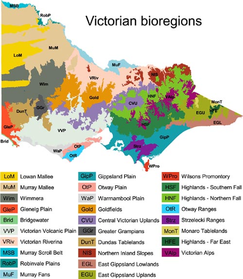
Bioregions
Bridgewater, located south-west Victoria, is a thin coastal plain of Tertiary and Quaternary deposits forming a barrier complex. A dune capped sand ridge stretches along the coastline with gently sloping sandy terrain and lagoonal systems behind. The lagoonal system supports a network of deep water pools, collapsed caverns or sink holes. The soils are a combination of siliceous sands (Podosols) on the dunes with underlying calcareous deposits giving rise to Calcarenite Dune Woodland and Coastal Dune Scrub. The lagoonal system sits on texture contrast soils, clays and peats (Chromosols, Vertosols, Hydrosols and Organosols) supporting Deep Freshwater Marsh and some Coastal Dune Scrub communities.
Ecological Vegetation Class Benchmarks of the Bridgewater Bioregion (PDF, 528.4 KB)
Ecological Vegetation Class Benchmarks of the Bridgewater Bioregion (Accessible) (DOCX, 455.4 KB)
Central Victorian Uplands, located in the central Victoria, is dominated by Lower Paleozoic deposits giving rise to dissected uplands at higher elevations, amongst granitic and sedimentary (with Tertiary colluvial aprons) terrain with metamorphic and old volcanic rocks which have formed steeply sloped peaks and ridges. The less fertile hills support Grassy Dry Forest and Heathy Dry Forest ecosystems. Herb-rich Foothill Forest and Shrubby Foothill Forest ecosystems dominate on the more fertile outwash slopes. The granitic and sedimentary (with Tertiary colluvial aprons) terrain is dominated by Grassy Woodlands much of which has been cleared. Lower lying valleys and plains are dominated by Valley Grassy Forest and Plains Grassy Woodland ecosystems.
Ecological Vegetation Class Benchmarks of the Central Victorian Upland Bioregion (PDF, 1.6 MB)
Dundas Tablelands, located in the south-west of the State, is predominantly a dissected tableland of Tertiary deposits overlaying a Palaeozoic palaeoplain. A hard ironstone layer caps the Palaeozoic deposits, resisting erosion. Streams have cut deep narrow valleys across the tablelands. Black earths (Dermosols) dominate the valleys and the dissected Merino Tablelands, yellow texture contrast soils (Chromosols and Sodosols) and cracking clays (Vertosols) dominate the rest of the table tops. The bioregion includes an area south of the Grampians which does not have such strongly expressed tableland features but does (did) support a similar range of ecosystems.
The vegetation is a complex mosaic of Plains Grassy Woodland, Damp Sands Herb-rich Woodland, Grassy Woodland and Creekline Grassy Woodland ecosystems.
Ecological Vegetation Class Benchmarks of the Dundas Tablelands Bioregion (PDF, 1.5 MB)
East Gippsland Lowlands is located south of the East Gippsland Uplands, stretching along the coast to far east Victoria. It has gently undulating terraces flanked by coastal plains, dunefields and inlets. A complex of Palaeozoic and Cainozoic deposits predominantly of granite, sands, marine sediments and beach deposits giving rise to yellow texture contrast soils (Kurosols and Chromosols) on the terraces, leached sands (Podosols and Tenosols) of the coastal plains and dunes, friable earths and texture contrast soils (Dermosols, Kurosols and Hydrosols) along the floodplains and valleys. Rainfall is spread fairly evenly throughout the year, with the greatest rainfall in November and the lowest in August. The majority of the southern section of the East Gippsland Lowlands bioregion adjoins the Gippsland Lakes or the ocean. High intensity rains at any time can cause flooding in the lower reaches of the creeks and rivers.
The vegetation is dominated by Lowland Forest with Damp Forest and Shrubby Dry Forest ecosystems interspersed throughout the foothills; Banksia Woodland and Riparian Scrub Complex are common around the coastal areas.
Ecological Vegetation Class Benchmarks of the East Gippsland Bioregion (PDF, 1.8 MB)
Ecological Vegetation Class Benchmarks of the East Gippsland Bioregion (Accessible) (DOCX, 1.6 MB)
East Gippsland Uplands consists of tablelands and mountains up to 1400 metres elevation. The geology stems from Palaeozoic deposits predominantly of granitic and sedimentary origin which give rise to red texture contrast soils (Kurosols and Chromosols) and brown and red friable earths (Dermosols, Kandosols and Ferrosols). Climate is temperate, averaging between 800-1200mm of rainfall a year.
The vegetation is dominated by Shrubby Dry Forest and Damp Forest on the upland slopes and Wet Forest ecosystems which are restricted to the higher altitudes; Grassy Woodland, Grassy Dry Forest and Valley Grassy Forest ecosystems are associated with major river valleys.
Ecological Vegetation Class Benchmarks of the East Gippsland Uplands Bioregion (PDF, 1.2 MB)
Gippsland Plain, located in the south east of Victoria, includes flat low lying coastal and alluvial plains with a gently undulating terrain dominated by barrier dunes and floodplains and swampy flats. The soils associated with the upper terrain are both texture contrast soils (Chromosols, Sodosols) and gradational texture soils (Dermosols), and typically support the Lowland Forest ecosystem. The dunes are predominantly sandy soils (Podosols and Tenosols) supporting Heathy Woodland and Damp Sands Herb-rich Woodland ecosystems. The fertile floodplains and swamps are earths and pale yellow and grey texture contrast soils (Hydrosols) and support Swamp Scrub, Plains Grassy Woodland, Plains Grassy Forest, Plains Grassland and Gilgai Wetland ecosystems.
The bioregion is generally below 200 m above sea level while the coastline includes sandy beaches backed by dunes and cliffs, and shallow inlets with extensive mud and sand flats. The bioregion has a temperate climate, averaging between 500 to 1100mm a year. The majority of rain falls in winter, and the Strzelecki Ranges create a rain-shadow to the east. A number of rivers drain the bioregion including the Avon, Bass, Latrobe, Macalister, Mitchell, Tambo, Tarwin, Thompson and Yarra.
Ecological Vegetation Class Benchmarks of the Gippsland Plain Bioregion (PDF, 1.6 MB)
Ecological Vegetation Class Benchmarks of the Gippsland Plain Bioregion (Accessible) (DOCX, 2.0 MB)
Glenelg Plain, located in the south west of the State, is a series of long low narrow ridges running parallel to the present coastline. These Cainozoic deposits give rise to pale acidic sandy dunes and humic acid sands on the flats (Podosols), dominated by Plains Grassy Woodland. On the red earths (Dermosols and Calcarosols), and acidic texture contrast soils (Kurosols) in the swales. Coastal communities are composed of beach and dune vegetation, including a largely unvegetated dune system with lakes that support wetland vegetation. Geomorphic significant basaltic sea caves occur along adjoining coastline with extensive coastal cliffs, salt marshes and wet heathlands. The vegetation is dominated by Damp Sands Herb-rich Woodland, Heathy Woodland, Herb-rich Heathy Woodland.
Ecological Vegetation Class Benchmarks of the Glenelg Plain Bioregion (PDF, 1.4 MB)
Ecological Vegetation Class Benchmarks of the Glenelg Plain Bioregion (Accessible) (DOCX, 1.4 MB)
Goldfields, located in central Victoria, is dominated by dissected uplands (predominantly a northerly aspect) of Lower Palaeozoic deposits. Metamorphic rocks have formed steeply sloped peaks and ridges. A variety of relatively poor soils are dominant with yellow, grey and brown texture contrast soils (Chromosols and Sodosols) and minor occurrences of friable earths (Dermosols and Ferrosols).
The climate is temperate with uncertain rainfall varying from 400 to 700 mm per annum, usually higher in winter. Maximum temperatures range from 12 to 32 degrees Celcius, daily minima range from 2 - 15 degrees. Box Ironbark Forest, Heathy Dry Forest and Grassy Dry Forest ecosystems dominate the lower slopes or poorer soils. The granitic and sedimentary (with Tertiary colluvial aprons) terrain is dominated by Grassy Woodlands much of which has been cleared. Occasional low-lying corridors of alluvial valleys between the uplands are dominated by Low Rises Grassy Woodland and Alluvial Terraces Herb-rich Woodland ecosystems.
A number of regionally important rivers transect the bioregion, mostly from south to north flowing into the Murray, and include the Wimmera, Avoca, Loddon, Campaspe and Goulburn Rivers. The Hopkins River is an exception, in that it drains south to Bass Strait.
Ecological Vegetation Class Benchmarks of the Goldfields Bioregion (PDF, 1.1 MB)
Ecological Vegetation Class Benchmarks of the Goldfields Bioregion (Accessible) (DOCX, 1.3 MB)
Greater Grampians, located in east Victoria, is dominated by prominent ridges of resistant sandstone giving rise to striking parallel ranges and forming valleys which have been cut either in soft shales or deeply weathered granites. The steep escarpments and gentle back slopes give the area a majestic beauty. The Palaeozoic deposits give rise to deep acidic yellow texture contrast soils (Kurosols) and shallow sandy soils (Rudosols).
The rocky outcrops support Rocky Outcrop Shrubland and Rocky Outcrop Herbland ecosystems; Hills Herb-rich Woodland occurs on fertile hills and Heathy Dry Forest occurs on the less fertile hills; the fertile plains and valleys support Plains Grassy Woodland and on sandy flats (many with impeded drainage) Heathy Woodland, Sand Heathland and Damp Sands Herb-rich Woodland ecosystems are dominant
Ecological Vegetation Class Benchmarks of the Greater Grampians Bioregion (PDF, 1.4 MB)
Highlands- Fare East Bioregion, located in the far east of Victoria, covers the broad escarpment particularly around Errinundra where the Monaro Plateau extends into Victoria and then falls sharply to the south-east. These dissected uplands have moderate to steep slopes and scarps, high and intermediate level plateaus, gorges and alluvial flats along the main valleys. The geology predominantly consists of Palaeozoic sediments, intrusive volcanics (granitic material) and extrusive volcanics (acid volcanics e.g. rhyolite). The brown and red porous earths (Dermosols) occur in the upper reaches and yellow,brown and red texture contrast soils (Chromosols and Kurosols) graduate down the valleys and in lower rainfall areas. The vegetation is dominated by Wet Forest on the upper slopes in the high rainfall areas with Cool Temperate Rainforest in the protected gullies. Montane Wet Forest occurs on the most sheltered wet sites at higher montane elevations and Damp Forest replaces Wet Forest at lower elevations.
Ecological Vegetation Class Benchmarks of the Highlands-Far East Bioregion (PDF, 373.3 KB)
Highlands - Northern Fall, located in the central part of Eastern Victoria, is the northerly aspect of the Great Dividing Range. These dissected uplands have moderate to steep slopes, high plateaus and alluvial flats along the main valleys. The geology is of Palaeozoic deposits giving rise to predominantly sedimentary and granitic rocks. The brown and red porous earths (Dermosols) occur in the upper reaches and yellow and red texture contrast soils (Chromosols and Kurosols) graduate down the valleys.
The vegetation is a mosaic of Herb-rich Foothill Forest and Shrubby Dry ecosystems dominating large areas of lower slopes; Montane Dry Woodland and Heathy Dry Forest ecosystems on the upper slopes and plateau; and Grassy Dry Forest and Valley Grassy Forest ecosystems associated with major river valleys.
Ecological Vegetation Class Benchmarks of the Highlands-Northern Fall Bioregion (PDF, 1.3 MB)
Highlands - Southern Fall, located in the central part of eastern Victoria, is the southerly aspect of the Great Dividing Range. These dissected uplands have moderate to steep slopes, high plateaus and alluvial flats along the main valleys. The geology is of Palaeozoic deposits giving rise to predominantly sedimentary and granitic rocks. The brown and red porous earths (Dermosols) occur in the upper reaches and yellow and red texture contrast soils (Chromosols and Kurosols) graduate down the valleys.
The dominated vegetation is Shrubby Dry Forest and Damp Forest on the upper slopes, with Wet Forest ecosystems dominant in the valleys including Cool Temperate Rainforest in the most protected gullies; Montane Dry Woodland, Montane Damp Forest and Montane Wet Forest ecosystems occur in the higher altitudes.
Ecological Vegetation Class Benchmarks of the Highlands- Southern Fall Bioregion (PDF, 1.4 MB)
Lowan Mallee, located in the east of the state, is typified by white siliceous sand formed into a complex array of jumbled irregular and parabolic dunes with intervening sand sheets and plains of this white sand and clayey deposits. The Cainozoic deposits of siliceous sands, clay, silt and mobile dunes give rise to leached sands (Podosols and Rudosols) and mottled yellow and grey texture contrast soils in the swales (Sodosols).
The vegetation is dominated by Lowan Sands Mallee with some Chenopod Mallee in the Sunset Country and Sandplain Heath, Mallee Heath, Loamy Sand Mallee, Scrub-pine Woodland, Broombush, Red-Swale Mallee, Yellow Gum Woodland and Heathy Woodland in the Big and Little Deserts.
Ecological Vegetation Class Benchmarks of the Lowan Mallee Bioregion (PDF, 942.6 KB)
Ecological Vegetation Class Benchmarks of the Lowan Mallee Bioregion (Accessible) (DOCX, 1.2 MB)
Monaro Tablelands, located in the north east of Victoria, is part of a higher-altitude tableland adjacent to the Alps that consists of undulating rises with occurrences of low hills and depositional flats with a high organic content. The geology consists of granitic and sedimentary deposits that give rise to predominantly yellow and brown texture contrast soils (Sodosols and Chromosols).
The vegetation is dominated by Montane Dry Woodland, Montane Grassy Woodland, Montane Riparian Woodland and Tableland Damp Forest ecosystems.
Ecological Vegetation Class Benchmarks of the Monaro Tablelands Bioregion (PDF, 699.9 KB)
Murray Fans, located in north central Victoria, is characterised by a flat to gently undulating landscape on recent unconsolidated sediments with evidence of former stream channels, braided old river meanders and palaeochannels and broad floodplain areas associated with major river systems and prior steams (known as braided / anastomosing streams). Alluvium deposits from the Cainozoic period gave rise to the red brown earths and texture contrast soils (Chromosols and Sodosols).
The vegetation is a mosaic of Plains Grassy Woodland, Pine Box Woodland, Riverina Plains Grassy Woodland and Riverina Grassy Woodland ecosystems.
The bioregion covers the margins of six separate drainage basins; the Broken River, Goulburn River, Campaspe River, Loddon River, Avoca River and the Mallee.
Ecological Vegetation Class Benchmarks of the Murray Fans Bioregion (PDF, 1.3 MB)
Ecological Vegetation Class Benchmarks of the Murray Fans Bioregion (Accessible) (DOCX, 1.2 MB)
Murray Mallee, located in the north west of the state, is typified by calcareous material in the form of broad undulating sandy plains that is often associated with linear, east-west aligned, low sand dunes with intervening heavier textured swales developed from Cainozoic deposits of alluvial, aeolian and swampy deposits. The vegetation is dominated by East/West-Dune Mallee with some Chenopod Mallee and Shallow-Sand Mallee.
The plains, drainage lines and groundwater discharge landscapes are dispersed with salt lakes and gypsum flats with lunettes developed on the eastern margins of the lakes. The Cainozoic deposits give rise to calcareous earths (Calcarosols), cracking clays (Vertosols), red sands (Rudosols). The vegetation is dominated by Gypseous Plains Shrubland, Saline Shrubland (Raak), Plains Grassland and Drainage-line Grassy Woodland.
The bioregion has few surface water bodies due to highly permeable soils and climatic conditions. The Murray river forms the north edge for the bioregion and the Avoca River roughly defines the eastern edge.
Ecological Vegetation Class Benchmarks of the Murray Mallee Bioregion (PDF, 1.1 MB)
Ecological Vegetation Class Benchmarks of the Murray Mallee Bioregion (Accessible) (DOCX, 1.0 MB)
Murray Scroll Belt, located in the far north west of the state, is an entrenched river valley and associated floodplain, including lake complexes of numerous oxbow lakes, billabongs, ephemeral lakes, swamps and active meander belts. The River Murray forms a narrow valley where fluvial processes predominate within an otherwise aeolian-dominated landscape. Alluvium deposits from the Cainozoic period gave rise to the red brown earths, cracking clays and texture contrast soils (Dermosols, Vertosols, Chromosols and Sodosols) which support Alluvial-Plain Shrubland, Riverine Grassy Chenopod Woodland and Riverine Grassy Forest ecosystems
Ecological Vegetation Class Benchmarks of the Murray Scroll Belt Bioregion (PDF, 748.9 KB)
Northern Inland Slopes, located in the north east of Victoria, consists of foothill slopes and minor ranges separated by river valleys that drain northward from the High Country to the Murray River. It is a mixed complex of geology's both granitic and metamorphic, which protrudes through and is surrounded by the Riverine Plain. The Warby Ranges is of granitic and sedimentary origin, Mt. Major is of volcanic and Terrick Terrick and Pyramid Hill are of granitic origin. The soils are predominantly texture contrast (Chromosols and Sodosols) apart from the Mt Major area (Ferrosols, Calcarosols and Vertosols).
The vegetation is dominated by Grassy Dry Forest, Box Ironbark Forest, Granitic Hills Woodland, Heathy Dry Forest and, Shrubby Dry Forest ecosystems on the less fertile hills; Herb-rich Foothill Forest ecosystems on the more fertile hills and outwash; and Grassy Woodland, Valley Grassy Forest, Plains Grassy Woodland, Floodplain Riparian Woodland, Riverine Grassy Woodland, Riverine Sedgy Forest and Wetland ecosystems on the fertile plains and watercourses.
Ecological Vegetation Class Benchmarks of the Northern Inland Slopes Bioregion (PDF, 1.7 MB)
Otway Plain, located in the south west Victoria, includes coastal plains and dunes, foothills with river valleys and swamps in the lowlands. Ridges mark the positions of successive shorelines associated with the long-term retreat of the sea. The soils associated with the upper terrain are texture contrast soils (Chromosols and Sodosols) and gradational texture soils (Dermosols), supporting Lowland Forest and Heathy Woodland ecosystems. The dunes are predominantly sandy soils (Podosols and Tenosols) and the floodplains and swamps are earths and pale yellow and grey texture contrast soils (Hydrosols) supporting predominantly Grassy Woodland and Plains Grassy Woodland ecosystems. The soils of the western half of the bioregion are generally acidic and of variable fertility. The coastal plains around Anglesea have sandy soils of low fertility, while the volcanic soils of the Bellarine Peninsula and clay soils around Werribee are more fertile.
Ecological Vegetation Class Benchmarks of the Otway Plain Bioregion (PDF, 1.6 MB)
Ecological Vegetation Class Benchmarks of the Otway Plain Bioregion (Accessible) (DOCX, 1.5 MB)
Otway Ranges, located in south-west Victoria, consists of moderate to steep slopes, deeply dissected blocks of alternating beds of sandstone, siltstone and shales, and swampy alluvial fans in the lowlands. The geology is of Mesozoic non-marine deposits covered with a veneer of younger Cainozoic deposits at lower elevations. Brown earths and brown texture contrast soils (Chromosols, Kurosols and Sodosols) occur throughout the bioregion with leached sands (Podosols) in the lowlands.
The dominant vegetation is Wet Forest, Shrubby Wet Forest and Cool Temperate Rainforest ecosystems on the higher slopes; and Shrubby Foothill Forest on the lower slopes.
In the wetter areas of the bioregion, strongly acid, well-drained gradational soil profiles rich in organic matter are found. Soil textures on Cretaceous sandstones and mudstones are moderately heavy, while those on Tertiary sediments range from sands to clay loams (Pitt 1981). Climate of the Otway ranges is generally cool and wet. Rainfall varies from 800 to 2000 mm per annum across the bioregion, with a strong seasonal peak in winter and the highest rainfall levels close to the main ridge (elevation between 500-700m). This ridge is frequently shrouded in mist and hence often has high humidity. The warmest months are January and February with mean daily maximum temperatures ranging from 21 to 25ºC. In the coolest months the mean daily maximum is as low as 9ºC and the mean minimal range from 3 to 7ºC. The coastal areas tend to have a milder climate, with fewer frosts and less temperature variation between winter and summer. A number of regionally important rivers originate in the Otway ranges and eventually flow to the sea including the Gellibrand, Ford, Aire, Parker, Barham, Barwon, Kennett, Cumberland and Erskine Rivers.
Ecological Vegetation Class Benchmarks of the Otway Ranges Bioregion (PDF, 1.1 MB)
Ecological Vegetation Class Benchmarks of the Otway Ranges Bioregion (Accessible) (DOCX, 873.4 KB)
Robinvale Plain, located in the north west of the state, is predominantly a narrow gorge confined by the cliffs along the Murray River - which is entrenched within older up-faulted Cainozoic sedimentary rocks. Alluvium deposits from the Cainozoic period gave rise to the red brown earths, cracking clays and texture contrast soils (Vertosols, Chromosols and Sodosols) this supports Riverine Grassy Forest and Riverine Grassy Chenopod Woodland ecosystems.
Ecological Vegetation Class Benchmarks of the Robinvale Plain Bioregion (PDF, 836.7 KB)
Ecological Vegetation Class Benchmarks of the Robinvale Plain Bioregion (Accessible) (DOCX, 1.0 MB)
Strzelecki Ranges, located in south east Victoria, consists of moderate to steep slopes, deeply dissected blocks of alternating beds of sandstone, siltstone and shales, and swampy alluvial fans in the lowlands. The geology is of Mesozoic non-marine deposits covered with a veneer of younger Cainozoic deposits including newer basalts. The soils are mainly gradational textured acidic soils (Dermosols) together with friable red earths (Ferrosols).
The dominant vegetation is Wet Forest and Damp Forest on the higher slopes; and Shrubby Foothill Forest and Lowland Forest on the lower slopes.
The climate is temperate with rainfall of 1000mm, mostly in winter and spring. The Strzelecki Ranges area a deeply dissected range of hills that form the headwaters of several river.
Ecological Vegetation Class Benchmarks of the Strzelecki Ranges Bioregion (PDF, 784.5 KB)
Victorian Alps, north east Victoria, consists of a series of high plateaus and peaks along the Great Dividing Range. The Palaeozoic deposits predominantly of granitic and basaltic origin give rise to friable leached earths, loams and peaty soils (Tenosols and Organosols). This bioregion has a cool climate with snow in winter, a short summer and annual rainfall above 1000m.
The vegetation associated with the subalpine plateaus are Sub-alpine Woodland, Treeless Sub-alpine Mosaic and Sub-alpine Grassland ecosystems and the upper slopes and generally surrounding sub-alpine areas are dominated by Montane Dry Woodland, Montane Damp Forest, Montane Wet Forest and Montane Grassy Woodland ecosystems.
Ecological Vegetation Class Benchmarks of the Victorian Alps Bioregion (PDF, 829.1 KB)
Ecological Vegetation Class Benchmarks of the Victorian Alps Bioregion (Accessible) (DOCX, 844.0 KB)
Victorian Riverina, located north of the Great Dividing Range in Victoria, is characterised by flat to gently undulating landscape on recent unconsolidated sediments with evidence of former stream channels and wide floodplain areas associated with major river systems and prior streams. Alluvium deposits from the Cainozoic period gave rise to the red brown earths and texture contrast soils (Chromosols and Sodosols) which dominate the Riverine Plain.
Annual average rainfall for the region ranges from 360- 672mm per annum. The average annual minimum and maximum temperature range is from 3 to 9 °C and 15 to 21 °C respectively. The vegetation is dominated by Plains Grassy Woodland, Plains Grassland, Pine Box Woodland/Riverina Plains Grassy Woodland Mosaic, Riverine Grassy Woodland/Riverine Sedgy Forest/Wetland Mosaic, Plains Grassy Woodland/Gilgai Plains Woodland/Wetland Mosaic, Grassy Woodland and Wetland Formation ecosystems. The Victorian Riverina bioregion is associated with the eight river basin tributaries of the Murray River draining north, west and south west from the Great Dividing Range of eastern Australia. However some rivers, such as the Avoca, drain internally into a series of terminal lakes and wetlands.
Ecological Vegetation Class Benchmarks of the Victorian Riverina Bioregion (PDF, 1.5 MB)
Victorian Volcanic Plain, located in west Victoria, is dominated by Cainozoic volcanic deposits. These deposits formed an extensive flat to undulating basaltic plain with stony rises, old lava flows, numerous volcanic cones and old eruption points and is dotted with shallow lakes both salt and freshwater. Numerous volcanic cones dot the landscape with scoria cones being the most common (e.g. Mt Elephant, Mt Napier and Mt Noorat) although some basalt cones are present (e.g. Mt Cottrell).
Soils are generally shallow reddish-brown to black loams and clays. They are fertile and high in available phosphorous. Older flows in the Cressy and Hamilton areas have allowed a greater development of deep soils. Dark saline soils occur around the margins of some lakes.
The soils are variable ranging from red friable earths and acidic texture contrast soils (Ferrosols and Kurosols) on the higher fertile plain to scoraceous material, and support Plains Grassy Woodland and Plains Grassland ecosystems.
Calcareous sodic texture contrast soils grading to yellow acidic earths (Chromosols and Sodosols to Dermosols), on the intermediate plain, and grey cracking clays (Vertosols) on the low plains, support Stony Knoll Shrubland, Plains Grassy Woodland and Plains Grassy Wetland ecosystems.
On the stony rises (volcanic outcropping) the stony earths (Dermosols and Tenosols) support Stony Rises Herb-rich Woodland, Basalt Shrubby Woodland and Herb-rich Foothill Forest ecosystems.
Wetland formations include inland salt marshes, permanent and intermittent freshwater and saline/brackish lakes, permanent freshwater ponds and marshes and inland, subterranean karst wetlands. The region is characterised by a rainfall of 450-840mm per annum, with a relatively even distribution throughout the year. The main river systems include the Maribyrnong, Werribee, Moorabool, Barwon, Corangamite, Hopkins, Glenelg and Merri Rivers, and Mount Emu and Leigh Creeks.
Ecological Vegetation Class Benchmarks of the Victorian Volcanic Plain Bioregion (PDF, 1.7 MB)
Warrnambool Plain extends along the coast from Portland to Moonlight Head. It consists of a distinctive cliffed coastline and low calcareous dune formations, dissected by rivers, inlets and swamplands. The Cainozoic sediments and volcanic deposits dominate the area giving rise to sandy soils (Calcarosols and Tenosols and Podosols) on the dunes and cliffline, Brown earths and texture contrast soils (Dermosols, Sodosols) on the flat plain, and texture contrast soils and fertile peats (Hydrosols) in the swamplands. Much of the limestone has been overlain by more recent sediments, and between the limestone dunes, areas of swamplands are characterised by highly fertile peats and seasonal inundation. The area east of Warrnambool is characterised by deeper soils of volcanic origins overlying limestone, which are dissected by streams. The Port Fairy area also features basalt flows with associated basalt coastal outcrops.
Average annual rainfall ranges from 700-1000 mm (varying across the bioregion) and falls mainly during winter and spring. The average maximum temperatures range from the about the 20oC on the coast to about 27oC inland. In winter the average maximum temperatures are about 13oC along the coast and 10oC inland.
Vegetation is dominated by Lowland Forest and Herb-rich Foothill Forest ecosystems, and in the swamplands, Damp Sands Herb-rich Woodland/Damp Heathland/Damp Heathy Woodland, Damp Heathland/Damp Heathy Woodland, Damp Heath Scrub, Damp Sands Herb-rich Woodland and Swamp Scrub ecosystems.
Significant wetlands include the Yambuk and Lower Merri wetlands. The bioregion also encompasses the lower portions of the Surrey, Fitzroy, Eumeralla, Hopkins and Gellibrand Rivers.
Ecological Vegetation Class Benchmarks of the Warrnambool Plain Bioregion (PDF, 1.0 MB)
Wilsons Promontory is located in south east Victoria and lies entirely within the Wilsons Promontory National Park. It is a spectacular area of rocky hills and mountains, dense heathy lowlands, sweeping white sandy beaches and prominent granite headlands surrounded by the cold waters of Bass Strait. The geology consists of Palaeozoic granites and deep Quaternary sand deposits.
Acidic texture contrast soils (Kurosols) and earths (Dermosols) are associated with the granitic terrain, and are dominated by Wet Forest, Granitic Hills Woodland, Lowland Forest, Shrubby Foothill Forest and Damp Forest ecosystems. Pale sands and sandy earths (Podosols, Tenosols and Rudosols) are associated with the sandy terrain, and mixture of wet soils (Hydrosols) associated with swamp deposits are dominated by Wet Heathland, Sand Heathland, Heathy Woodland and Riparian Scrub ecosystems
Ecological Vegetation Class Benchmarks of the Wilsons Promontory Bioregion (PDF, 655.9 KB)
Wimmera, located in the far west of the central Victoria, is typified by flat to gently undulating plains in the east, with black and grey cracking clay soils (Vertosols). Plains Woodland, Plains Grassy Woodland, Plains Grassland, Red Gum Wetland and Grassy Woodland are the dominant ecosystems. The western part is typified by ancient stranded beach ridges with interspersed with clay plains (where there are a mixture of swamp, lakes, lagoons and lunettes in the south) with cracking clay soils and red texture contrast soils (Vertosols and Sodosols). The vegetation on these less fertile plains is dominated by Heathy Woodland and Shallow Sands Woodland
Ecological Vegetation Class Benchmarks of the Wimmera Bioregion (PDF, 1.6 MB)
Ecological Vegetation Class Benchmarks of the Wimmera Bioregion (Accessible) (DOCX, 2.0 MB)
Ecological Vegetation Classes, Bioregional Conservation Status and Benchmarks
Ecological Vegetation Classes (EVC) are the standard unit for classifying vegetation types in Victoria. EVCs are described through a combination of floristics, lifeforms and ecological characteristics, and through an inferred fidelity to particular environmental attributes. Each EVC includes a collection of floristic communities (i.e. lower level in the classification) that occur across a biogeographic range, and although differing in species, have similar habitat and ecological processes operating.
To view the distribution of EVCs across the state see NatureKit
Ecological Vegetation Class (EVC) benchmarks relate to a single EVC within one bioregion. They have been developed to assess the vegetation quality of EVCs at the site scale in comparison to a 'benchmark' condition. These benchmarks have been developed to assess native vegetation using the method for Vegetation Quality Assessment (VQA) .
The EVC mapping includes units called mosaics, complexes and aggregates and generic wetland mapping units. These are mapping units only, and should not be used to assess a site using the VQA. As such, there are no benchmarks available for these units. In these cases, the site should be assessed using the component EVC that is dominant on-site.
EVC 'variants' and those EVCs that are known to exhibit structural variation across their range will also need to utilise on-site information to determine the appropriate benchmark to apply.
The EVC benchmarks contain a subset of "typical" but not comprehensive lists of species for each EVC in a bioregion. It should also be noted that not all species listed in the benchmark will be appropriate to all sites across the range of an EVC in a bioregion nor readily available through local nurseries.
The table below provides information for mapped wetland areas that have not yet been assigned a wetland EVC type or are known to comprise an aggregate of wetland EVCs due to their temporal nature. Please keep in mind your purpose for assessing a wetland area and make sure you use the appropriate benchmark.
Generic wetland EVC - lookup table (Excel, 46.5 KB)
The combination of EVC and bioregion is used to determine the bioregional conservation status (BCS) of an EVC. This is a measure of the current extent and quality for each EVC, when compared to it's original (pre-1750) extent and condition. On this basis a BioEVC will have a BCS of endangered, vulnerable, depleted, least concern or rare. Download the MS Word or PDF document below for Bioregional Conservation Status for each BioEVC.
Bioregional Conservation Status for each BioEVC (PDF, 1009.4 KB)
Bioregional Conservation Status for each BioEVC (Accessible) (DOCX, 502.7 KB)
Contact us: For further information, email Biodiversity.info@delwp.vic.gov.au
Criteria for Bioregional Conservation Status of Ecological Vegetation Classes (EVC)
Presumed Extinct
Status code: X
Probably no longer present in the bioregion (the accuracy of this resumption is limited by the use of remotely - sensed 1:100 000 scale woody vegetation cover mapping to determine depletion - grassland, open woodland and wetland types are particularly affected).
Endangered
Status code: E
Contracted to less than 10% of former range; OR
Less than 10% pre-European extent remains; OR
Combination of depletion, degradation, current threats and rarity is comparable overall to the above:
- 10 to 30% pre-European extent remains and severely degraded over a majority of this area; or
- naturally restricted EVC reduced to 30% or less of former range and moderately degraded over a majority of this area; or
- rare EVC cleared and/or moderately degraded over a majority of former area.
Vulnerable
Status code: V
10 to 30% pre-European extent remains; OR Combination of depletion, degradation, current threats and rarity is comparable overall to the above:
- greater than 30% and up to 50% pre-European extent remains and moderately degraded over a majority of this area; or
- greater than 50% pre-European extent remains and severely degraded over a majority of this area; or
- naturally restricted EVC where greater than 30% pre-European extent remains and moderately degraded over a majority of this area; or
- rare EVC cleared and/or moderately degraded over a minority of former area.
Depleted
Status code: D
Greater than 30% and up to 50% pre-European extent remains; OR
Combination of depletion, degradation and current threats is comparable overall to the above and:
- greater than 50% pre-European extent remains
- and moderately degraded over a majority of this area.
Rare
Status code: R
Rare EVC (as defined by geographic occurrence) but neither depleted, degraded nor currently threatened to an extent that would qualify as Endangered, Vulnerable or Depleted.
Least Concern
Status code: LC
Greater than 50% pre-European extent remains and subject to little to no degradation over a majority of this area.
Page last updated: 02/10/23